 |
|
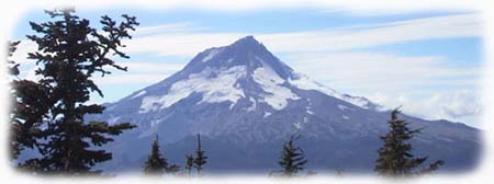
The Cascade range is really two mountain ranges in one. Along the west front of the range, the Old Cascades are a steep collection of weathered, ancient peaks whose volcanic phase is long over. They are now shaped only by rain, snow and wind. The crest of the Old Cascades reaches between 4,000 and 5,000 feet in elevation. The High Cascade peaks rise on top of the Old Cascades, and are the familiar volcanic giants of the Pacific Northwest - mountains like Hood, Rainier, St. Helens, Adams and Jefferson, to name a few. The High Cascade volcanoes often top 10,000 feet in elevation, and are still a volcanic work in progress, shaped by periodic eruptions, glaciers, rain and wind. Lookout Mountain doesn't fit either of these descriptions. It is a huge shield volcano, more like the peaks that form the Hawaiian islands than the steeper High Cascade peaks. To the north and east, its forested slopes gently descend toward the Columbia River, and its northern flanks are dotted with small volcanic cones and "prairies" of wildflowers. To the south and west, the mountain's face is defined by massive faults, with steep cliffs and ravines that drop thousands of feet into the Hood River and Badger Creek valleys. At 6,525 feet, the summit of Lookout Mountain is significantly higher than most Old Cascade peaks, yet is not tall enough to qualify as a major peak. Instead, it provides a stunning view of the east face of Mount Hood (below), and other High Cascade peaks from the Three Sisters in central Oregon to Mount Rainier in Washington. |
 |
|
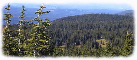
Beyond its unusual geology, Lookout Mountain is also at the nexus of several climate zones. To the west are the green forests of the High Cascades, dominated by Douglas fir and lush forest understory, and rainfall in excess of 100 inches annually. To the east are rare Ponderosa pine and Oregon oak parklands, where open wildflower gardens grow in the open forests. Here, only 10 to 20 inches of rain falls annually. In between these extremes is an unusual mix of forest and grassland species from both desert and mountain provinces. Near the summit, the peak is also home to whitebark pine, subalpine fir, mountain hemlock and many alpine wildflowers. It's easy to visit Lookout Mountain. A short 1.2 mile trail leads from High Prairie (pictured below) to the summit at a gentle grade, following an old lookout road. Other, steeper and longer paths climb to the summit, as well. One route climbs 3,000 feet up the southwest face of the mountain from the East Fork of the Hood River. Though beautiful, this 5.2 mile route is a stiff climb for most hikers. |
 |
|
Other approaches include routes from Badger Creek and the spectacular Divide Trail, which climbs 4.2 miles from the Flag Point Lookout on the east shoulder of the mountain along a high, open ridgecrest of wildflower gardens and spectacular rock formations. Most trailheads require a Northwest Forest Pass to park your car. These can be purchased at Forest Service offices or various local vendors. Trailheads are reached by driving east of Portland on Highway 26 over Mount Hood, and then on Highway 35 to the East Fork of the Hood River. Here, the Gumjuwac trail begins near the Robinhood Campground. A few miles further, Forest Road 44 joins Highway 35, and provides access to the High Prairie and Flag Point trailheads. Forest Road 44 is paved, and continues past Lookout Mountain to the town of Dufur, where the Barlow District Ranger District that manages the Lookout Mountain area is based. Lookout Mountain is usually snow-free from early July through mid-October. However, the elevation can make for very cold weather even on sunny days, so always pack a jacket. Also, the only reliable water supply on the hike is at Senecal Spring, located on a marked spur trail just below the east face of the mountain. The best plan is to bring plenty of water on your hike. Finally, stay on trails or obvious use paths during your visit. The tiny wildflowers that grow on the high slopes are too fragile to withstand much traffic. Staying on worn paths allows everyone to enjoy the mountain in its full summer glory. |
|
 |
|
|
|
|