 |
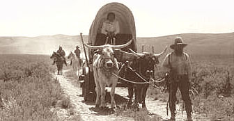
The first settlements in the area were along the eastern foot of Lookout mountain, on the Fremont pioneer trail that led settlers south from the Oregon Trail at The Dalles toward California. This route passed through the future townsites of Dufur, Friend and Tygh Valley. |
|
Along this section of the Fremont pioneer road, the route passed through the open Oregon oak and Ponderosa pine stands unique to the east slope of Lookout Mountain. Streams that flow from the vast, gentle north slope of the peak were named for the point at which they crossed the route: Threemile, Fivemile, Eightmile and Fifteenmile Creeks. |
 |
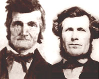 |
In 1845, pioneer Samual Barlow (left in photo) found a new route over the Cascades by following the White River from Tygh Valley to present-day Government Camp, then down the Zigzag and Sandy River valleys to Oregon City. In 1846, he completed a road over the new route, with the help of Joel Palmer (right), who was also the first white man to attempt to climb Mount Hood. Today, Palmer Glacier provides the nation's only year-round skiing at Timberline Lodge, and Highway 26 forms a major transportation route over Barlow Pass, closely following Sam Barlow's original pioneer road. |
|
First called Fifteenmile Creek, Dufur was established in 1872 when Andrew and Burnham Dufur bought a farm where Dufur is now situated. The brothers were part of a Wasco County family that had arrived from New England in 1859. The town grew at the lower end of a fertile valley, and farmsteads spread along the rushing, clear waters of Fifteenmile Creek. By the late 1800s, Dufur had grown into a thriving agricultural town, and was surrounded by the world's largest apple orchard. Today, fields of wheat and alfalfa are grown in the Dufur Valley, and cherry orchards grow on the surrounding hills. Pictured here is one of three historic churches in Dufur. |
 |
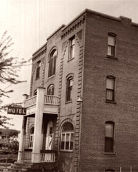 |
In 1907, the brick Dufur Hotel was constructed at the south end of Main Street. Though vacant for a period, the structure still survives and is again operating as a hotel. By the early 1900s, Dufur had become a hub for agriculture and trade in the area, and also served mills located on the slops of Lookout Mountain. Highway 44 is still called Dufur Mill Road. Today, Dufur caters to tourists with a collection of nineteenth century buildings and historical museum located in a log cabin on Main Street. Kramer's Market still operates in a century-old building in the heart of the tiny business district, and is still family-owned and operated. |
|
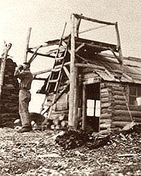
By the early 1900s, the Oregon National Forest had been established, encompassing most of the Oregon Cascades. Fire lookouts were constructed on high peaks throughout the range to spot fires and prevent forests from burning. In 1911, the Guard Station at High Prairie was constructed, and an adilade established on the summit of Lookout Mountain, giving the peak it's name. In 1914, this log cabin was constructed on top of the peak, including a rooftop spotting platform. |
 |
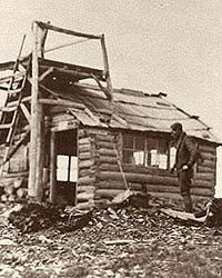 |
Another view of the first lookout building on the summit of Lookout Mountain, taken sometime in the early 1900s. A ten-foot enclosed tower was built in 1930. It served for a decade in the newly-named Mount Hood National Forest, one of many new national forests that replaced the original Oregon National Forest. During this period, a dense network of trails was also completed, many by Depression-era CCC crews, connecting Lookout Mountain to nearby Flag Point, Badger Creek, Gumjuwac Saddle and Fifteenmile Creek. |
|
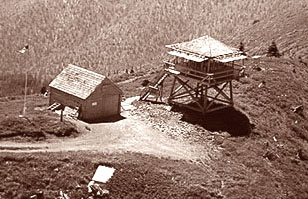
In 1940, this lookout structure and storage barn was built on the summit, and served until it was decommissioned in 1966. These structures have since been removed, but the foundation for the storage barn and footings for the lookout structure can plainly be seen today. The foundation for the storage barn still shows the construction date of 1930. |
 |