|
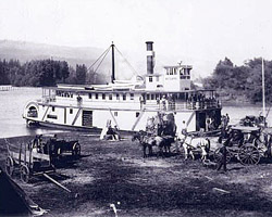
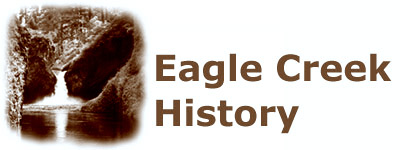
The modern history of Eagle Creek began with the arrival of European settlers in the 1840s. The Oregon Trail brought immigrants to The Dalles, and many paid to float their covered wagons through the Columbia Gorge on rafts, braving the Cascades of the Columbia, near the mouth of Eagle Creek. This homestead and mill was photographed at the mouth of the creek in 1867. Later, fishwheels were built here to harvest the huge salmon runs. |
 |
|
|
By the late 1800s, river traffic had grown to include steamers. Ship access greatly increased commercial development of the Gorge, including extensive logging, fishing and grazing. Settlements with streamer landings grew with the new resource economy. During this period, rail lines were also built through the gorge, on both sides of the river. Yet, the frequent landslides and flooding that disrupted rail service kept steamers on the river for decades, until roads were built. |
|
The Columbia River Gorge Park was established in 1915 as a unit of the Oregon National Forest, and was the first time the Forest Service had dedicated an area to purely recreational use. The "park," some 22 miles long and four to six miles wide (13,873 acres) along the Oregon bank of the Gorge was closed to timber sales and resort development, and set a national precedent for national forest policy. |
 |
|
|
As part of providing recreation access in the new park, the Forest Service built the Eagle Creek Campground during the summer of 1916. It was a "fully modern" facility with tables, toilets and a ranger station. In addition, construction began on the 13.5 mile long Eagle Creek trail. The trail was built for scenery, blasted into sheer basalt cliffs to provide the best views. By 1919, nearly 150,000 people enjoyed the Eagle Creek facilities each summer. |
|
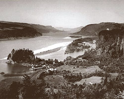
From 1914 through 1922, the Columbia River Scenic Highway was constructed, bringing the first automobiles to the Columbia Gorge, and forever changing the role of the area into a recreation haven. The Eagle Creek Bridge was especially unique, designed by engineer Samual Lancaster as a concrete arch with a facing of basalt that gave it the appearance of the great Swiss highway structures that inspired the Columbia River Scenic Highway. |
 |
|
|
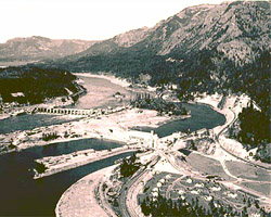
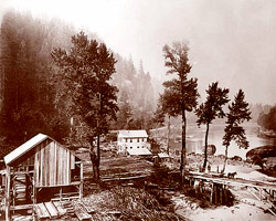
In the 1930s, Bonneville Dam became the first of the Columbia River basin projects to be constructed. Eagle Creek canyon enters the Gorge in the upper left of this photo, just upstream from the dam. Powerlines were draped across the gorge, but fortunately missed most of Eagle Creek. Accompanying the dam was the Eagle Creek Fish Hatchery, which still operates today, near the mouth of the creek, adjacent to the Scenic Highway bridge over Eagle Creek. |
|
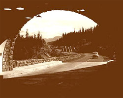
In 1949, the nation's highway building bonanza came to the Columbia Gorge, with a new, river-level highway replacing the suddenly obsolete Columbia River Scenic Highway. The Tooth Rock Tunnel (right) cut through the rock bluff at the mouth of Eagle Creek, under the older highway viaducts that wound around Tooth Rock. Later, construction of a new powerhouse at Bonneville caused the partial collapse of the older viaducts. |
 |
|
|
By the late 1950s, as Oregon celebrated it's centennial, the highway was designated as Interstate-90N, and was a major transportation link. The road was later expanded to four lanes, requiring a new highway viaduct at Tooth Rock, and converting the new tunnel to eastbound traffic only. At this time, the Columbia River Scenic Highway was completely abandoned in the vicinity of Eagle Creek, though the historic highway bridge remained. |
|
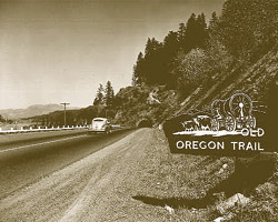
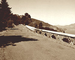
By the 1990s, appreciation for the Historic Columbia River Highway finally spurred state and federal transportation officials to restore what remains of the route (the photo shows a restored section near Mosier). The restoration included a reconstruction of portions of the original Tooth Rock viaduct, and a new stairway that provides access to the restored route. This section is now only open to pedestrians and cyclists. |
 |